Category Archives: Blog
Invitation: Mapping a Colony
Sunday, November 12, 17-19
Astrid Noacks Atelier (ANA)
Rådmandsgade 34, 2200 København N, Denmark
In conjunction with the exhibition, Performing Archive: Estate Bethlehem, ANA welcomes a work-in-progress presentation of ‘Mapping a Colony’ (https://mappingacolony.org). This online interactive mapping project seeks to connect areas of Denmark to its former colonies and to visualise the data for a worldwide reach, making this history ‘present’ and accessible to the public. This outreach event with wine and snacks offers some behind the scenes insight into the project and aims to encourage public engagement and participation by anyone wishing to share their personal archives, narratives and knowledge.
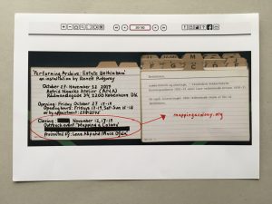
Performing Archive: Estate Bethlehem
October 27 – November 12, 2017
Astrid Noacks Atelier (ANA)
Performing Archive: Estate Bethlehem is a solo multimedia exhibition at Astrid Noack’s Atelier (ANA) from October 27 – November 12th 2017 by artist and researcher Renée Ridgway. The ‘transfer year’ 2017 marks the 100-year purchase of the former Danish West Indies by the United States for $25,000,000 in gold. This installation shows the transformation of the Bethlehem sugar plantation on St Croix, USVI through the lens of archival images during three distinct periods in history (plantation, factory, cultural centre). This installation draws on archival images from the National Archive of Denmark, the Royal Library, the USVI archive from the Library of Congress U.S., along with photos and video interviews gathered during a recent research trip to St Croix. The archives were first searched, then subjectively selected, thereby decontextualized from their collection and now (re)presented in situ at ANA forming a new archive. Historical documents, internet images and personal objects also surface, emulating the nature of migrating archives into the public sphere. From Danish colonial plantation maps, photographs of the past century by American imperialists, to present-day cultural activism, Performing Archive: Estate Bethlehem reflects a piece of land denatured by slavery, labour and trade and offers a view on the impact of these histories in the contemporary as well as their current politics.
Thanks to: Nanna Bonde Thylstrup, Mette Kia Krabbe Meyer, Niklas Thode Jensen, Percival Edwards, Luis Cumo, Per Lachmann, William Clelland, George Tyson, Kirsten Dufour, Finn Andersen, Jakob Jakobsen, Uncertain Archives participants and programme 2016-2017.
The exhibition is open Fridays: 17-19, Saturdays and Sundays: 15-18 until November 12, 2017 and by appointment: +4523812345 or rr@reneeridgway.net
Mapping Experiments
Mapping Experiments
Written by Marie Blønd, Lab Manager in ETHOS Lab
The Danes entered St. Croix in the West Indies in 1672 as merchants with dreams of trade and cultivating the land. What may have seemed like an innocent act of drawing out the islands and making maps, became one of the first tools to be used in the future Danish colonization of the islands. Mapping out the land and thus dividing it into plots, makes it possible to claim ownership and begin to trade the land and the people inhabiting it. Maps are never innocent and carry authority by presenting ‘knowledge’ or ‘facts’.
Over 350 years later, ETHOS lab is involved in prototyping ‘mapping a colony’. A Danish colonization that once was and still carries traces and stories. A subdued heritage full of contradictions; shame, national pride, regrets, denial, wealth and ethics. A heritage primarily represented by Danish archives and Danish accounts of a colonial era – Danish fragments. It matters who makes the maps and tells the stories. Therefore, this project seeks to include not just Europeana’s archives but build a collaborative mapping practice seeking out other representational voices in remembering and living the colonial subdued heritage. Instead of using the map to conquer, it is the intention to be used for countering. Counter-mapping the dominating Danish colonial narratives and telling stories that include among others, the island’s voices and remembrance. This has been a challenge, since the islanders did not have access to tools such as photography and writing or had the resources to creating and maintaining archives. One of the representatives of the island’s voices is La Vaughn Belle. She enlightened us on how the colonial past of the islanders were often remembered through the passing of songs from one generation to another. How can these colonial fragments be included in the fragmental map making? How can we dig out the underrepresented voices and put them on the map?
As the name of the Royal Library’s exhibition ‘Blind Spots’ and the article by Information suggests, then it matters whose eyes that sees. Archival material, as the material presented on the exhibition created blind spots, as it matters how the material representations are made, from where and by whom and for which purpose. Archival material are thus far from neutral facts telling the whole story but rather skewed from the points of view of the producers of these materials and their privileges as well as politics. We could say, that the same applies for the project ‘Mapping a Colony’.
The idea for the project was suggested and driven mainly by writer Lene Asp and somehow born out of a previous event ‘Mapping History through Data’ where ETHOS Lab at IT University of Copenhagen, HUMLab at Copenhagen University and the Royal Danish Library collaboratively experimented with what stories may appear from the digital Danish colonial archives. A collective and collaborative effort in experimenting with how and why a mapping could represent multiple data types and stories.
Mapping a Colony is expanding this idea by including other archives and voices. An attempt to gather forgotten and non-archival fragments of remembrance, stitching together an alternative map-making and collaboration. With inspiration from La Vaugh Belle assembling fragments of ‘Chaneys’, pieces of Danish porcelain dug up on the islands and shaped into valuables by the locals, the project is piecing together a map to represent colonial heritage from multiple perspectives and particular past and present collective memory.
Geographical markers are not used as representing facts or an exercise in scale-making but are incomplete fragments to tell stories of the interrelatedness and consequences of the subdued colonial heritage. Any map-maker will therefore notice the absence of timescale and see it as the missing link or blindpost. But time is also a representation making events happen in a linear format. What if, time is collapsed as a statement of past and present being entangled and intertwined?
In ETHOS Lab we aim to take on projects as experimentation. Experimentation in methods, scale-making, temporalities or baseless data. Mapping is a method used in diverse disciplines and many of our experiments often presents maps either in geographic, network, temporal or poetic constellations. We try to perform what we call ‘Situated Analytics’, a place in-between algorithmic performativity and ethnographic inquiry. Focus is on the process rather than the actual product, a conversation rather than productivity, or maybe we could call it performing interdisciplinarity.
Our involvement in this project was initially to make a website with a geographical map, a map of contents from both existing archives and archives stitched together by ‘Uncertain Archives’ engaged collaborators and underrepresented voices from the islands. Our role also became a contribution to the thought experiment of mapping as a method in a situated account of colonial memory and as a counteract to previous dominating narratives of Danish colonial power. This blog raises questions and reflections on mapping a colony as a method or productive failure.

Why Mapping?
Maps are abstractions, representing ways of knowing and are often an authoritative power tool. Although, maps also restricts, refrains and hides based on the priorities and decision making of the map-maker. Geographical authoritative maps were initially used when the Danes colonized the islands, as a tool to document the islands and separate it into blocks of ownership (LINK TO ARTICLE on BLIND SPOTS talking about map-making). Thus, it was one of the tools used to colonize the land and the people putting to the forefront Danish ownership and rule.
Archives represent fragments and biased views on what Danish Colonialism once was and how we relate to it today.
Using a geographical map is a reductionist format of collaboratively piecing together fragments, like Chaneys and filling out the gaps intentionally to make coherent stories. Although, the geographical map is restricted to places, points, markers and incorporating people and stories was the work of assembling ‘Chaneys’ into a what seems like a coherent whole.
Helen Verran states that method is a story and which stories are we bringing to life in this experiment? Maybe this is a trickster. A trickster still waiting to show itself, hidden in the reflective gaps and restrictions of using a geographical map as the representation of stories. Maybe this is what we mean when we call it a prototype, represented in a blog-format maintained beyond funding.
Hello, world!
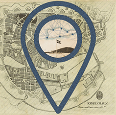
A Visual Experiment
By undertaking a counter-mapping, we are contesting historical and geographical maps that bear the imprint of grand colonial narratives. As an evolving working platform, this site does not offer a chronological order of events, but instead foregrounds the interconnection of places, people and themes across and between Denmark and the USVI.
The project is also a collaborative effort that encompasses multiple data contributors from different parts of the world who have provided entries about places, people, and material from a broad range of archives, i.e. the Library of Congress and the Royal Library. By including these many voices (and more to come) we hope that we can facilitate a multi-layered and multi-temporal reflexive approach to the places we live and inhabit today. We are of course aware that no archive is neutral and this is no exception. The map also carries the traces of our own interaction with the archival material and the people with whom we are in contact.
Prototyping and Counter-mapping
In many ways this project was always already a failed one. As the gridded town plan of St. Croix (USVI) clearly demonstrates, the map is also a colonial way of seeing and inhabiting space. And our own biases, even those of which we are unaware, produce blind spots on the map. The stories presented on this map express partial views, fragments of stories, with no intention of claiming objectivity. Instead they attest to the complexity of daily life and of historicizing. They are, rather, expressions directly related to our situated interaction with the historic and archival material at our disposal, here and now. However, taking failure as a productive process, it is our hope that we can glean meaningful conversations from the project about the inherent difficulties of working with contested digital archival material such as this.
Taking center stage, then, are the unfolding relations between people and places across time, in an experiment of prototyping and counter-mapping. This prototyping works with some inbuilt assumptions, that history is still working in the present and is shaped by our continuous engagement with it. Moreover, that there is an inbuilt political choice in seeking to counteract the dominant form of present-day Danish accounts that claim engagement with the USVI is ‘a thing of the past.’ As such we are inspired by scholars who critically engage with newly-digitized material from the Danish West Indies, most notably: Temi Odumosu, Katrine Dirkinck-Holmfeldt, Mette Kia Krabbe Meyer, Mathias Danbolt and others.
Incentives and Involvement
Mapping a Colony is first and foremost a digital humanities project, funded by Europeana, which consists of an ongoing exploration of the traces, influences and consequences of Danish slavery and colonial cultural memory. The project is collaborative in form because it brings together contributions from people living in the USVI, Denmark and elsewhere, representing various knowledge fields.
By curating data from various sources and presenting it through an alternative digital mapping, we hope that the project will help shed light on the Danish-USVI colonial past and bring forward yet undiscovered links and voices from the past and present, history and memory, culture and economy. We hope our work also serves educational purposes with regard to framing the ethics of analyzing, mapping, visualizing and designing digital interactions with archival material.
The project’s incentive is to discuss the cultural and ethical potential of archival use and reuse. While mass digitization opens up the circulation and distribution of digital images and archival records, it also gives rise to new ethical, political and methodological questions concerning the re-use of such material. The project’s production process confirms a need for ongoing discussion of these questions.
Follow our work and events on the blog and read more about the people behind the project here.
- Explore the Map by clicking on various points of interest.
- Let us guide you through connected stories via the Narratives.
- Take a virtual tour of the past in the Gallery.